

How Mobile Mapping Delivers Better Surveys in Less Time
Key Takeaways
Mobile mapping technology is revolutionising land surveying by delivering unprecedented speed, safety, and accuracy for large-scale infrastructure projects.
- Mobile mapping systems can survey 50 km or more in just one day, reducing project timelines from weeks to days whilst maintaining sub-centimetre accuracy.
- Projects typically achieve 30-70% cost reductions compared to traditional methods through dramatically reduced field time and labour requirements.
- Engineers collect comprehensive data safely from vehicles at highway speeds, eliminating dangerous roadside work and traffic disruptions.
- High-resolution LiDAR and GPS technology capture billions of data points per second, creating detailed 3D models ready for BIM and GIS integration.
- The technology seamlessly integrates with modern design platforms, supporting everything from initial planning to ongoing asset management throughout a project’s lifecycle.
This transformative approach to surveying represents not just an efficiency gain but a fundamental shift towards safer, more cost-effective infrastructure development that delivers superior results in a fraction of the traditional timeframe.
Ultimately, the article serves as a resource for infrastructure professionals looking to make a well-informed decision on adopting modern, highly efficient surveying services in Ireland.
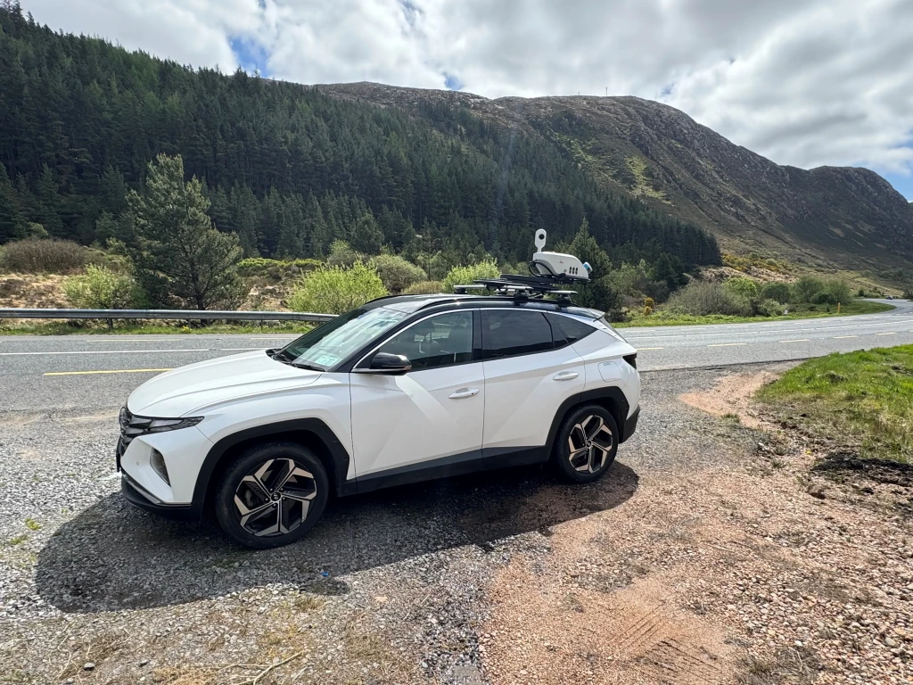
Mobile mapping has revolutionised the way we conduct land surveying, making it possible to cover vast distances in remarkably short timeframes. Since the late 1980s, at least 1000 land-based mobile mapping systems have been in operation around the world, performing rapid geospatial information acquisition for various applications.
The efficiency gains are staggering, while a conventional surveying team, along with a traffic management crew, would need at least 6 weeks to measure a 50-km road. With mobile mapping, we can complete the same task in about a week, with the actual driving taking only two hours.
At its core, mobile mapping refers to the process of collecting geospatial data using LiDAR sensors, IMUU, cameras, and GPS technology mounted on vehicles or other mobile platforms. This rapidly evolving technology enables real-time data capturing and visualisation, offering significant advantages for topographical surveys and land surveying projects of all scales.
Furthermore, mobile mapping systems collect real-time spatial information that can be processed into detailed 3D deliverables, supporting everything from design planning to environmental assessments. As surveying services in Ireland and beyond continue to adopt these innovative approaches, the combination of speed, accuracy, and safety presents compelling reasons to consider mobile mapping for your next project.
Why mobile mapping is changing land surveying
Traditional land surveying is being rapidly transformed by mobile mapping technology. The shift is happening because the advantages are too significant to ignore.
Speed and safety advantages over traditional methods
The efficiency gains of mobile mapping are remarkable. Traditional surveying methods often take days or weeks to complete, especially for large areas. In contrast, mobile mapping systems capture billions of data points in just a few hours. What truly demonstrates this efficiency is the ability to survey over 50 km in a single day, dramatically reducing project timelines and associated costs.
Safety improvements represent another compelling advantage. Mobile mapping significantly reduces the need for surveyors to work in potentially dangerous environments such as busy roadways. This eliminates requirements for signage, spotters, Traffic Management Operatives, and lane closures, cutting both risk and cost simultaneously.

How mobile mapping supports topographical surveys
Mobile mapping combines accuracy with efficiency for topographical surveys. The technology integrates various sensors, including GNSS, LiDAR, and high-resolution cameras, to create comprehensive data sets. This integration enables the rapid creation of detailed 3D models, digital twins, and accurate maps with enhanced precision compared to traditional methods.
For topographical work, mobile mapping delivers various outputs, including:
- 2D and 3D CAD drawings and detailed site surveys
- 3D point clouds for precise modelling
- BIM-ready models for design integration
- Digital terrain models for planning purposes
Use in surveying services across Ireland and beyond
Across Ireland, mobile mapping has proven particularly valuable for infrastructure projects. It’s especially beneficial where deadlines are tight, site access is limited, or large areas must be mapped accurately the first time.
Road and rail engineers throughout Ireland prefer this technology because it enables data collection at standard traffic speeds. Additionally, large-scale rail projects benefit from mounting mobile mapping platforms on trains, allowing surveys at commuter speeds with minimal disruption.
Beyond transportation, mobile mapping supports urban planning, disaster response, and water infrastructure assessment. In Ireland, firms like IO Geomatics highlight that what takes traditional teams four days, mobile mapping can complete in just two hours, making it an increasingly essential tool for surveying services nationwide.
How engineers can survey up to 50+ km in 24 hours

Modern surveying teams are accomplishing what was once unthinkable, capturing detailed topographical data across 50+ km of terrain in just one day. The secret lies in a streamlined, technology-driven approach that maximises efficiency at every stage.
Step-by-step breakdown of a mobile mapping survey
The mobile mapping process begins with thorough planning. Initially, surveying engineers scope the site, assess access points, and develop optimal routes to maximise coverage. For road projects, this often involves coordinating with authorities to ensure minimal disruption during data collection.
Subsequently, control points are established. These critical reference markers, typically installed every 100 metres along the survey route, provide the foundation for accurate georeferencing. This strategic preparation ensures the resulting data will align precisely with existing coordinate systems.
Equipment setup and calibration
Before data collection begins, precise calibration is essential. The heart of most mobile mapping systems includes high-resolution LiDAR scanners, GNSS receivers, and inertial measurement units (IMUs), often complemented by 360 cameras.
Calibration involves several crucial steps. First, system components must be aligned and synchronised to work in unison. Moreover, the second GNSS antenna is typically mandatory in rail environments to ensure accurate dynamic performance of the IMU by continuously calibrating it to eliminate drift. Proper calibration delivers sub-centimetre precision, with some systems achieving accuracy within 10mm.
Data collection at highway speeds
Once calibrated, mobile mapping systems can capture data at remarkable speeds, up to 100 km/h. This allows engineers to survey extensive stretches of infrastructure without disrupting traffic flow.
During collection, LiDAR scanners record millions of points per second, building a comprehensive digital model of the surrounding environment. A typical highway project that would take weeks using traditional methods requires just hours with mobile mapping. One case study demonstrated completing a 12km survey of a busy town in Wicklow in 3 hours..
Post-processing and 3D model generation
After field collection, the raw data undergoes several processing stages. The workflow typically follows three main steps: registration (alignment of point clouds using Rinex), ground control tie-in, and final optimisation through bundle adjustment to minimise residual drifts.
The final deliverables often include dense 3D point clouds, digital surface models, orthophotos, and reports, all tied to the chosen coordinate system and ready for import into design platforms like AutoCAD, Revit, or GIS systems. The resulting models support everything from construction planning to asset management with survey-grade accuracy.
Key benefits of mobile mapping for large-scale projects
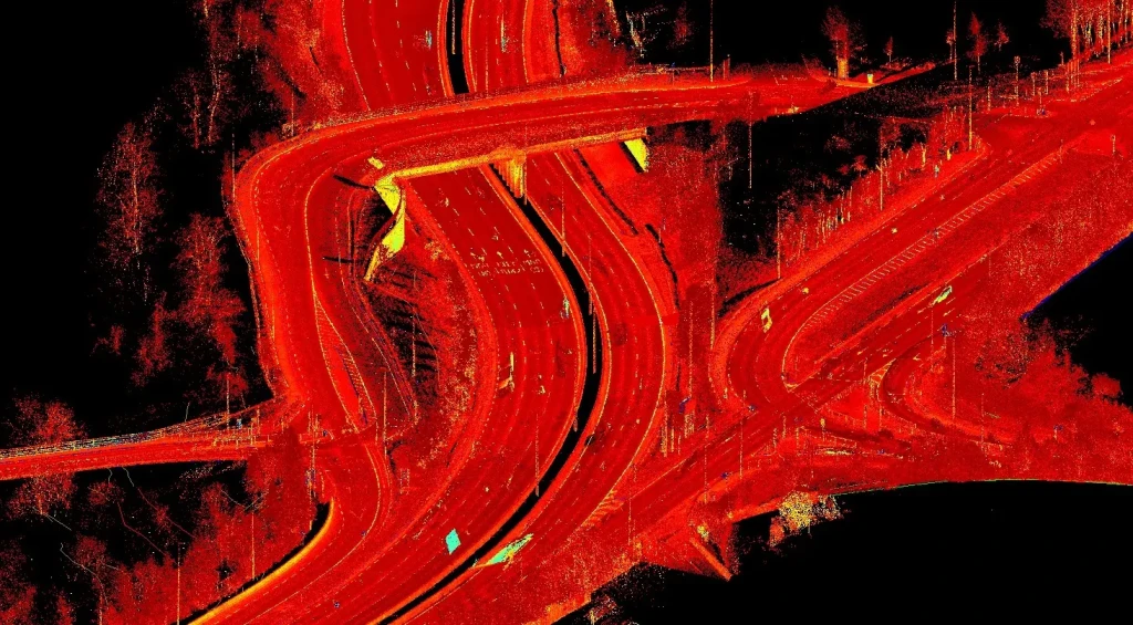
Large-scale infrastructural projects gain numerous advantages from mobile mapping solutions. The economic and practical benefits make this technology increasingly essential for modern surveying companies.
Reduced field time and labour costs
The financial impact of mobile mapping is substantial, with contractors reporting a 50% reduction in data collection costs alongside a fourfold increase in productivity. One analysis concluded that mobile mapping resulted in a 40-70% cost reduction in field survey costs over traditional methods. Consequently, what once required teams of surveyors spending weeks on site can now be accomplished in hours.
High-resolution data for better planning
Mobile mapping systems capture extraordinarily detailed information at highway speeds. This comprehensive data includes:
- Terrain features and boundaries
- Asset inventories and utilities
- Full photographic records of route conditions
Indeed, the high-resolution output allows teams to extract additional information later without costly site revisits.
Minimising rework through accurate models
Rework can consume between 2%-20% of a project’s total budget. Accurate mobile mapping data helps project managers maintain tight specifications, identifying potential issues before they escalate. Through proper integration of ground control points (GCPs), these systems maintain global accuracy during repeated inspections.
Integration with BIM and GIS platforms
The convergence of mobile mapping with Building Information Modelling (BIM) and Geographic Information Systems (GIS) creates powerful digital twins. This integration enables better designs in a real-world context, making both construction and operations more efficient. Essentially, when GIS, CAD, and BIM connect, teams improve operability throughout a structure’s lifecycle while eliminating errors.
Choosing the right mobile mapping system or provider

Selecting the ideal mobile mapping solution requires careful evaluation of several key factors. Your project’s specific needs will determine which system or service provider will deliver optimal results.
What to look for in topographical survey companies
First, assess the provider’s hardware-software integration; streamlined workflows between synchronised components yield better outcomes. Also, examine their track record and reputation within the industry. Regarding equipment, consider how well the system handles varying temperature, humidity, shock and vibration conditions. Finally, verify what deliverables they provide, whether traditional AutoCAD drawings or newer formats like REVIT.
Comparing mobile mapping Dublin vs. rural areas
Urban and rural environments present distinct challenges. High-end systems excel in Dublin’s dense urban landscape, whereas cost-effective lower-end systems might suffice for less complex rural projects. Urban areas often require higher accuracy and detail due to complex infrastructure, though some projects need only 15-20mm accuracy regardless of setting.
When to use drones and surveying together
Drones perfectly complement mobile mapping when integrated strategically. While mobile mapping excels at road-level detail, drones provide valuable overhead perspectives. This collaboration delivers comprehensive site models by capturing data from multiple vantage points. For large-scale projects, drones survey approximately 200ha in just 2 hours of flying, making them ideal companions to mobile mapping systems.
Evaluating mobile mapping services in Ireland
Throughout Ireland, providers like IO Geomatics offer services that can survey over 50km daily. When evaluating providers, request demos in environments familiar to your projects. Additionally, examine their post-processing capabilities and software compatibility with your existing systems. Finally, assess whether their deliverables, including 2D/3D CAD outputs, 3D point clouds, or BIM-ready models, match your project requirements.
Conclusion
Mobile mapping truly stands as a game-changer for the surveying industry. Throughout this article, we’ve seen how this technology enables teams to cover 50+ km in just 24 hours, a task that would take weeks or even months using conventional methods. The benefits extend far beyond mere speed, though that alone justifies consideration for many projects.
Safety represents another compelling advantage. Surveyors now collect comprehensive data from the comfort and security of their vehicles, eliminating dangerous roadside work. Additionally, the remarkable precision of mobile mapping systems delivers sub-centimetre accuracy while capturing millions of data points per second.
Financial considerations make an equally strong case. Projects typically see 30-70% cost reductions compared to traditional surveying approaches. This efficiency stems from dramatically reduced field time and decreased labour requirements, creating substantial savings for infrastructure projects of all sizes.
The technology continues to evolve rapidly. Mobile mapping now seamlessly integrates with BIM and GIS platforms, creating powerful digital twins that support everything from initial design to ongoing maintenance. Furthermore, complementary technologies like drone surveying enhance these capabilities, offering comprehensive perspectives impossible to achieve through any single method.
Companies across Ireland have already embraced these advances, transforming how they approach major infrastructure projects. The question no longer seems to be whether to adopt mobile mapping, but rather which provider and system best match specific project requirements. After all, when a technology can deliver better results faster, safer, and more affordably, its adoption becomes less of a choice and more of a necessity for staying competitive in the modern surveying landscape.
Ready to revolutionise your next project with mobile mapping?
Contact IO Geomatics today to learn how we can help you achieve faster, safer, and more accurate surveys for your infrastructure needs.
FAQs
How does mobile mapping compare to traditional surveying methods in terms of efficiency?
Mobile mapping is significantly faster than traditional methods. It can survey over 50km in a single day, whereas traditional surveying of a 50km motorway would take approximately 6 weeks.
What are the key safety benefits of using mobile mapping technology?
Mobile mapping greatly enhances safety by reducing the need for surveyors to work in potentially dangerous environments like busy roadways. It eliminates the requirement for signage, spotters, operatives, and lane closures.
How accurate is mobile mapping technology?
Mobile mapping systems can achieve remarkable accuracy, with some systems delivering precision within 10mm. Proper calibration and integration of ground control points ensure high global accuracy during surveys.
What types of data can mobile mapping systems collect?
Mobile mapping systems collect comprehensive data, including terrain features, boundaries, asset inventories, utilities, and full photographic records of route conditions. They create detailed 3D models, digital twins, and accurate maps.
How does mobile mapping integrate with other technologies like BIM and GIS?
Mobile mapping data seamlessly integrates with Building Information Modelling (BIM) and Geographic Information Systems (GIS), creating powerful digital twins. This integration enables better designs in a real-world context, improving efficiency throughout a structure’s lifecycle.


